Exploration of search radius for GEON LiDAR Workflow
by Ramón Arrowsmith, November 2006
As part of our ASU/SDSC/UCSD GEON collaboration, we have built a high performance local gridding algorithm.
The initial development is explained in this link: Notes on LiDAR interpolation
An updated explanation and reference is our 2006 Fall AGU presentation by Kim, et al.: An Efficient Implementation of a Local Binning Algorithm for Digital Elevation Model Generation of LiDAR/ALSM Dataset
Given the search radius implementation, what does it actually look like with actual ALSM data, and what are the search radius tradeoffs?
This plot shows different search radius options as a function of the grid/DEM resolution (+ indicates grid node).
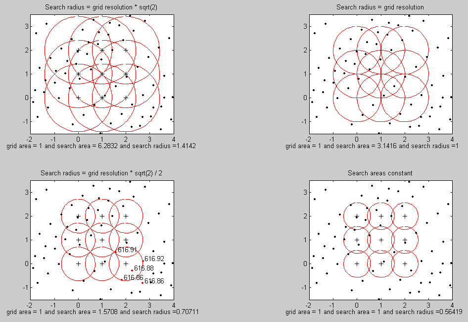
SearchRadius.pdf
The example is for the typical 1 m DEM and the data are actual B4 survey data from the Carrizo Plain (black dots). The red circles show the different search circles, while the annotation below indicates the search area and search radii as a function of grid/DEM area. We concluded that the optimal (and thus default for the GLW) search radius = (grid resolution * sqrt(2) / 2), or in this 1 m DEM case, search radius = 0.707 m. This option covers all of the survey, but does have a slightly larger search area (1.56 m2) than the grid area 1 m2. For some locations, however, it leaves a modest but notable amount of null cells in which no points are encountered. Thus, in practice, I have started to use the upper right case where the 1 m DEM is produced with a 1 m search radius (search area = 3.14 m2).
In addition, the figure shows the actual points in red with their elevations that are close to the search radius for the lower right node. Within the search radius, we operate on the selected points to produce the grid with a local minimum, maximum, mean, inverse distance weighted mean, and point count.
Code used for this analysis
searching.m--main script
circle.m--function to draw a circle
r144.txt--small piece of B4 data from Carrizo Plain area for example