Consideration of point count and optimal resolution and search radius for B4 ALSM data in the Carrizo Plain
by Ramón Arrowsmith, November 2006
As part of our ASU/SDSC/UCSD GEON collaboration, we have built a high performance local gridding algorithm.
The initial development is explained in this link: Notes on LiDAR interpolation
An updated explanation and reference is our 2006 Fall AGU presentation by Kim, et al.: An Efficient Implementation of a Local Binning Algorithm for Digital Elevation Model Generation of LiDAR/ALSM Dataset
Given the local gridding implementation, what is the optimal DEM resolution and search radius for B4 data in the Carrizo Plain?
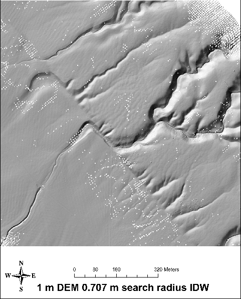
1 m DEM
498idwOverview.pdf
The above image shows the 1 m DEM produced with the default 0.707 m (grid resolution * sqrt(2) / 2) search radius. There are about 3000 null cells scattered thoughout the image because of the search radius relative to the shot distribution.

6209idwOverview.pdf
The above image shows the 1 m DEM produced with a 1 m search radius. According to the discussion presented here, I think this is the optimal combination for the 1 m DEM.
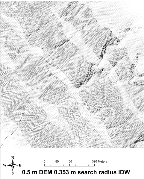
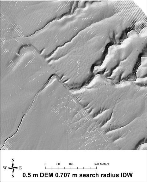
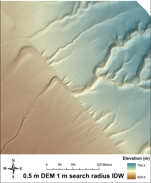
0.5 m DEM
3703idwOverview.pdf
The above image shows the 0.5 m DEM produced with the default 0.353 m (grid resolution * sqrt(2) / 2) search radius. There are about 600,000 null cells scattered thoughout the image because of the search radius relative to the shot distribution.
0703idwOverview.pdf
The above image shows the 0.5 m DEM produced with the default 0.707 m search radius. There are about 13,000 null cells scattered thoughout the image because of the search radius relative to the shot distribution.
6477idwOverview.pdf
The above image shows the 0.5 m DEM produced with a 1 m search radius. According to the discussion presented here, I think this is the optimal combination for the 0.5 m DEM.
Shot density
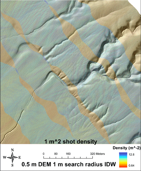
WCdensity.pdf
The above image shows the shot density per 1 m-2 over the 0.5 m DEM. Densities are as high as 12.8 shots per 1 m-2 in areas of swath overlap. Typical densities are 2-3 shots per 1 m-2 in areas of single swath and about 5 shots per 1 m-2 in double overlap.
Nulls versus search radius
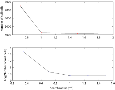
SearchRadius.pdf
The above plot shows the number of nulls per DEM versus search radius. The first value is the default search radius (grid resolution * sqrt(2) / 2) for the 0.5 m (upper) and 1 m (lower) DEMs. At about the 1 m search radius, the number of nulls become asymptotic to the minimum number of nulls defined but the strip at the edge of the data on the northeast (upper right) of the images.
Here is the matlab function that I used to count the nulls: load_dem.m.
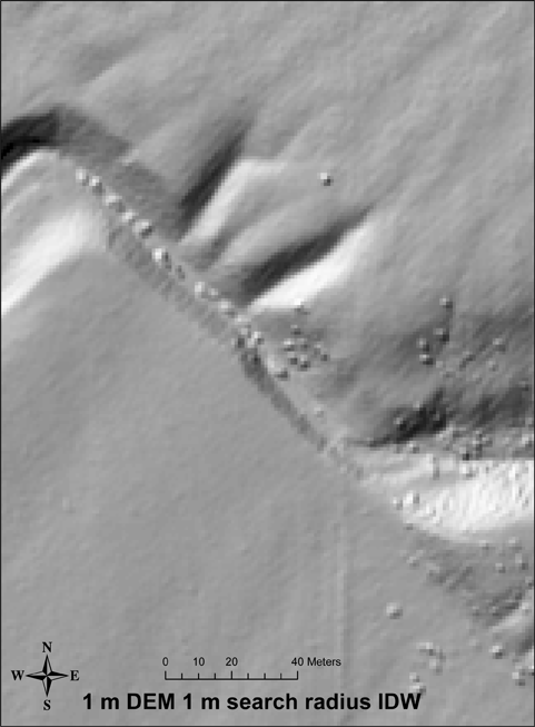
1 m versus 0.5 m resolution comparison
6209zoom.pdf
The above image shows the area of Wallace Creek at 1 m DEM with a 1 m search radius.
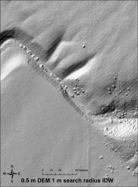
6477zoom.pdf
The above image shows the area of Wallace Creek at 0.5 m DEM with a 1 m search radius. Note the development of the "corduroy" as the resolution approaches the scan to scan distance from different swaths. The corduroy has amplitudes of about 20-30 cm. See this discussion for more on corduroy: http://lidar.asu.edu/KnowledgeBase/1233vs5100.html.