Home
Current Research
OpenTopography Portal
LViz: 3D LiDAR Visualization Tool
Points2Grid: LiDAR DEM Generation Tool
Data
Knowledge Base
Links
LiDAR LISTSERV
Active Tectonics Research Group


LiDAR / ALSM DataOnline LiDAR / ALSM data resources:
October 16, 1999 Hector Mine, CA earthquake (Mw 7.1) high resolution topography data set:A portion of the Hector Mine Earthquake LiDAR data set is available for download below. An overview of the data set can be found on Ken Hudnut's (USGS) page at http://rincon.gps.caltech.edu/.Detailed information about these data and their application is available in the Seismological Society of America (BSSA) Special Publication: The Hector Mine, California Earthquake of 16 October 1999:
Hector Mine ALSM / LiDAR data downloads:We have made a subset of the ascii formated return files from the Hector Mine data set available for download. The files are grouped by flight line and zipped for quicker download:
Flight 01 (includes files 1041.txt, 1081a.txt, 1081b.txt) (~60 MB - .zip file) Flight 03 (includes files 5121_03.txt, 5131a_03.txt, 5131b_03.txt) (~55 MB - .zip file) Lake Tests Maneuvers (includes files lake_01.txt and lake_03.txt) (~16 MB - .zip file) Bulion Line (includes files Bulion1.txt - Bulion5.txt) (~106 MB - .zip file) We have converted the Hector Mine Maneuvers and Bulion ALSM return data to shapefile format for import to ArcGIS:
Flight 1 (168 MB - .zip file) Flight 3 (153 MB - .zip file) Bulion Fault line of the Hector Mine laser survey Bulion shapefiles (304 MB - .zip file)
Bulion5 TIN (83.5 MB - .zip file) 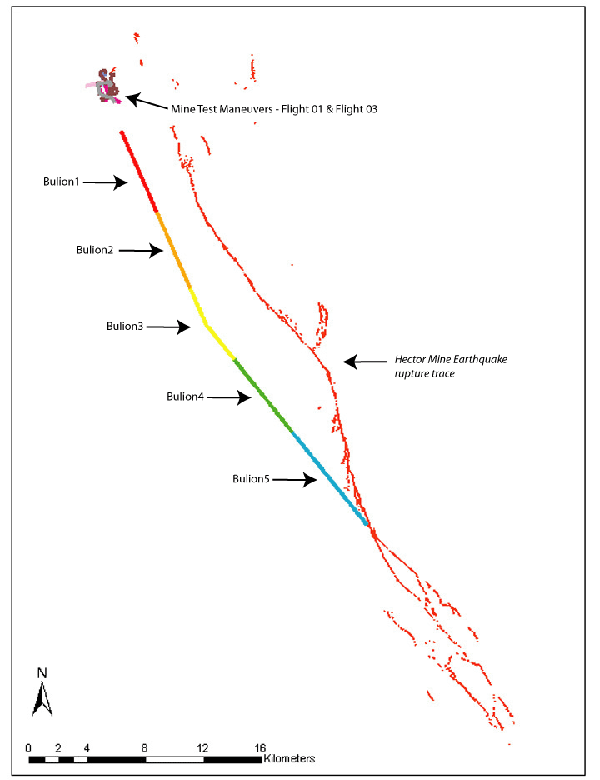 |
