GEON Points2Grid Utility
The GEON Points2Grid Utility is a lightweight tool for the generation
of Digital Elevation Models (DEMs) from LiDAR point cloud data.
The utility was developed by a team of geoscientist and computer
scientists at Arizona State University and University of California,
San Diego under National Science Foundation funding to the GEON
Project. The Points2Grid Utility utilizes a local binning algorithm
to offer rapid generation of DEMs from large volumes of LiDAR point
return data.
Points2Grid Instructions / Help document
GEON Points2Grid Utility Screen Capture:
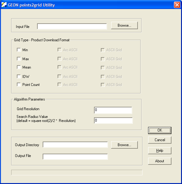
(click to view fullsize)
Points2Grid is an implementation of code developed
by Han S. Kim at UCSD. For more information please see:
Kim, H., Arrowsmith, J R., Crosby, C.J., Jaeger-Frank, E., Nandigam, V., Memon, A., Conner, J., Badden, S.B., Baru, C., An Efficient Implementation of a Local Binning Algorithm for Digital Elevation Model Generation of LiDAR/ALSM Dataset,
Eos Trans. AGU, 87(52), Fall Meet. Suppl., Abstract G53C-0921, 2006. [PDF of poster - 21.6 MB]
The tool offers user control over DEM resolution
and the local bin radius. Points2Grid operates on delimited ascii
LiDAR return data (one point per line, x,y,z + attributes) and DEMs
are output from the tool in either ESRI's Arc ascii grid or a standard
ascii grid format. Points2Grid is currently only compatible with Windows
operating systems. Although originally conceived for DEM generation
from LiDAR point data, Points2Grid can be used to grid any 3D point
cloud data such as seismicity or gravity.
The GEON Points2Grid Utility is an evolving piece of software, new
versions will be released periodically (see below for most recent
version).
VERSION HISTORY (changes, bug fixes and new features):
Version 1.3 (April 24, 2007):
- Fixes bug that limited out-of-core processing. P2G should now
be able to handle significantly larger volumes of point data.
- Updated instructional information (Help menu) with an FAQ section.
Version 1.2 (March 8, 2007):
- Integrates instructional information under the "Help" menu. Note: integrated Help files are not compatible with Microsoft's
Vista operating system.
- Minor changes to the user interface
- Fixes a bug that resulted in inexact grid cell dimensions in the ASCII Grid download format
Version 1.1: fixes a minor bug related to the file extension added to ascii grid files.
GEON Points2Grid Utility Version 1.0 (original release):
- Import of delimited ascii LiDAR return data
(one point per line, x,y,z + attributes)
- User control over DEM resolution and local bin radius
- Output of DEMs in either Arc ascii or standard ascii grid formats
Related Information:
|