Home
Current Research
OpenTopography Portal
LViz: 3D LiDAR Visualization Tool
Points2Grid: LiDAR DEM Generation Tool
Data
Knowledge Base
Links
LiDAR LISTSERV
Active Tectonics Research Group


Exploiting LiDAR for Regional Morphologic Correlation and Dating of Wave-cut and Fault-Controlled Landforms:Digital Elevation Models (DEMs) from LiDAR data (Light Distance and Ranging, a.k.a. ALSM - Airborne Laser Swath Mapping) collected across broad geographic regions provides a new tool for studying landscape response to tectonic deformation. LiDAR data can be exploited for landform correlation by conducting profile-based morphologic dating of fault scarps and marine, lake and fluvial shorelines (e.g. Hanks, 2000). The high density of these data allows numerous topographic profiles to be extracted from a DEM and analyzed for morphologic age (Crosby et al., 2004). Correlation from profile to profile can then be established by comparing morphologic age for various landforms in a research area.ABSTRACT: Crosby, C. J., Arrowsmith, J R., Oldow, J. S., Prentice, C. S., Exploiting LiDAR for Regional Morphologic Correlation and Dating of Wave-cut and Fault-Controlled Landforms, Eos Trans. AGU, 85 (47), Fall Meet Suppl., Abstract G13B-0810, 2004. 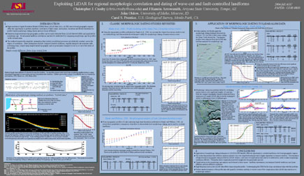 |
