Home
Current Research
OpenTopography Portal
LViz: 3D LiDAR Visualization Tool
Points2Grid: LiDAR DEM Generation Tool
Data
Knowledge Base
Links
LiDAR LISTSERV
Active Tectonics Research Group


Application of LiDAR data to constraining a late Pleistocene slip rate and vertical deformation of the Northern San Andreas Fault, Fort Ross to Mendocino, California:Collaborative research between Arizona State University and the U.S. Geological Survey. Funded by the National Earthquake Hazards Reduction Program (NEHRP) under grant no. 06HQGR0032The objective of this research is to analyze LiDAR (LIght Distance And Ranging) topographic data of the Gualala block section of the northern San Andreas fault (NSAF) and associated marine terraces between the towns of Fort Ross and Mendocino, California acquired in February of 2003 to gain earthquake hazard understanding for the NSAF. The purpose is twofold: (1) Characterize the tectonic geomorphology of the NSAF at various temporal and spatial scales in order to better understand SAF geometry, slip rate, slip distribution, and off-fault deformation as manifest in landscape development. (2) Demonstrate the utility of LiDAR data as a tool for studying tectonic geomorphology and earthquake geology, and develop methodologies for utilizing these types of data in determining geomorphic metrics to characterize surface processes and landscape history. Specifically, we are focused on the late Pleistocene marine terraces in this region and their importance in constraining a SAF slip rate at Alder Creek, near Point Arena, where the terraces are offset by the fault as it intersects the coast. In addition, we are analyzing the topography along the NSAF to constrain patterns of distributed, SAF-driven, deformation recorded in the landscape. Such patterns of deformation may reflect SAF geometry and may be useful for inferring rupture behavior and slip history. WORKSHOP REPORTS: Crosby, C. J., Arrowsmith, J R., Prentice, C. S., Application of LiDAR data to constraining a late Pleistocene slip rate and vertical deformation of the Northern San Andreas Fault, Fort Ross to Mendocino, California: Collaborative research between Arizona State University and the U.S. Geological Survey, in 4th Annual Northern California Earthquake Hazards Workshop abstract volume, Menlo Park, CA, January 18-19, 2007. 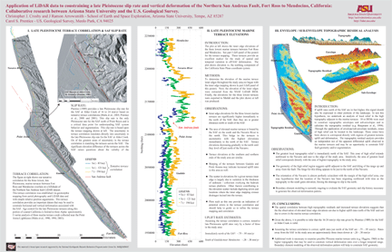 Crosby, C. J., Arrowsmith, J R., Prentice, C. S., Application of LiDAR data to constraining a late Pleistocene slip rate and vertical deformation of the Northern San Andreas Fault, Fort Ross to Mendocino, California: Collaborative research between Arizona State University and the U.S. Geological Survey, in 3rd Annual Northern California Earthquake Hazards Workshop abstract volume, Menlo Park, CA, January 18-19, 2006. RELATED PROJECTS:
LiDAR Data Distribution and Processing with GEON Cyberinfrastructure |
